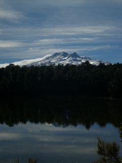
This is New Zealand though, always lots to do, so plan b was to catch a scenic flight over the three volcanoes and see them that way. Unfortunately as we woke this morning, the cloud cover was so low you could almost touch it. Instead we took the scenic route around the national park, the mountains still hiding behind clouds. Eventually we were far enough south to get out of the cloud cover and see Mount Ruapehu, New Zealands tallest volcano, in all it's glory (apart from the power cables obscuring the view...).
The volcano had erupted 8 months ago, and had a large eruption in 1996, so quite an active one! The 1996 eruption threw out 5 to 15 metre boulders (that must be like a house flying at you!) along with hot ash and other debris. The volcano is currently under alert as there is increased activity in the crater, meaning a possible eruption could occur. There was also a map indicating where lava flows and water from the crater lake would go if an eruption occurred. Came in quite useful for us when picking a campsite!