One last glacial trip…

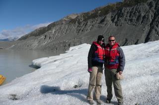
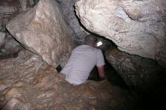
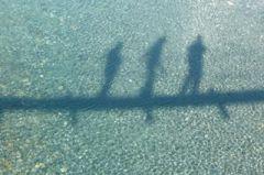
We’ve hiked on them, caught a helicopter halfway up them, drank them, climbed through them, photographed them (copiously), slept next to them, counted them, and watched bits of them float in a lake, so is there anything else you can do with glaciers? Yes there is. Turns out you haven’t seen the best of a glacier until you see it from the air. So that’s what we did today.
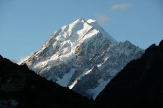
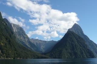
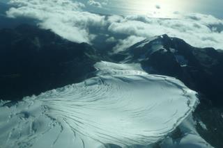
Taking to the air with me in the copilots seat, (and quietly trying to remember how that flight simulator game worked, just in case) we took to the air, flying up the glacier from yesterday and over the névé (the snow “lake” that the glacier flows from). The snow was pristine, untouched and ripe to jump into. Although it looked close, it was probably a long way down as the névé tend to be a few kilometres across, and those little cracks were probably a few hundred metres deep. New Zealand is meant to have about 3,000 glaciers, and up there it’s a lot easier to believe it as the mountain ranges stretch off to the horizon with peaks as far as the eye can see. The plane flew over the Fox and Franz Josef Glaciers, around a few peaks and then headed back. We also got some pretty awesome and up close views of Mount Cook, which left us feeling even more impressed with anyone who has ever climbed it.
I think it’s now safe to say that we’ve done glaciers, and they are surely the best thing to come out of getting water cold!

Iceberg dead ahead!

I’m never too wide awake and with it when emerging from the campervan in the morning, but the winter wonderland that greeted my eyes this morning was quite a surprise. When I say winter wonderland, it had hailed and snowed lightly in the night so it was like icing sugar everywhere. But seeing as we missed out on a winter (no sympathy required…), I feel the need to wax lyrical. With 6 layers of clothes on and a couple of cups of coffee, I was ready for the day ahead.
The valley glaciers around Mount Cook are unusual as they have huge lakes at the bottom, and as we’ve already walked on glaciers, we took to the water. Coming over the terminal moraine rocks, the huge murky grey lake spread out in front, and was dotted with icebergs huge and small that have broken off the front of the glacier, about 2kms further up the lake. The lifejacket made the layer total 7, and me look like the michelin man. Our little boat poked up to the icebergs, that look like ice islands, and to think that 90% of the iceberg is submerged! The ice itself is a strange patchwork of building blocks as it originates in the glacier where the ice cubes tumble over each other on the way down. Each iceberg is slowly dissolving, tipping up and occasionally turning over, although fortunately the one we had a little walk on stayed very still!
That evening, after a walk up to another iceberg lake at the foot of Mount Cook with views of at least 17 glaciers, we retreated to the Old Mountaineers Cafe and planted ourselves in front of the roaring log fire. Seriously contemplating a warm room in a lodge somewhere, we dragged ourselves back to the chilly campsite with it’s crystal clear night sky and moonlit glaciers. I think it’ll be another cold one tonight.

Mount Cook, and is that another glacier?

We almost missed out the return to Mount Cook, thinking that we saw the tallest mountain from the west coast when we were at the Fox/Franz Josef glaciers, and what’s the point of seeing it from the other side? It’s a good job we did come back, the view from the east is most definitely the better side.
The drive up passed by the turquoise blue glacial lakes which contrasted nicely with the autumnal orange trees. There were a few wisps of cloud hiding the peaks of the Mount Cook range as we drove up the huge glacial valley to the base of Mount Cook. It’s hard to imagine a glacier so large that it could fill the width and height of the valley, nevermind stretch more than 50km back to the mountains. Rounding the final bend we were treated to the face of a mountain with four glaciers clinging to the almost vertical rocks. It certainly is good to be back in glacier country again, although first call was the visitor centre to get more woolly clothing and have some hot chocolate!
The DoC campsite was literally walking distance to the Mueller Glacier, the second largest in New Zealand. (as I found out by accident after going for a short stroll, not something you expect!) So, unsurprisingly it was fairly cold that night, and as it’s the DoC, there’s no electricity to be leaving the fan heater on all night to keep warm!

Dunedin

Dunedin is named after Edinburgh, or more accurately, Edinburgh of about 600AD, before the Angles, er, Anglesized it! There are plenty of street and suburb names from Edinburgh, and there are plenty of old style buildings to match too, but there were only a couple of sights we really wanted to see before moving on (you’ll note the train station was obviously top of the list, but done yesterday 😉 ).
First up was Signal Hill, at the top of a very high and steep hill, but fortunately with a road all the way up. The memorial celebrates 100 years of colonial rule, but more importantly there is a lump of the real Edinburgh there, from castlehill itself. Next sight was also on the same steep hill, well it actually is the steep hill. Baldwin Street is the world’s steepest street, and we walked/ran/staggered up to the top, then watched the Japanese tourists do the same, along with a few cars at high speed. The walk down gave us chance to get more silly photos in the same style as San Francisco, as well as an excuse to run uncontrollably to the bottom.

Albatross!

With the Catlins Coast behind us, we popped into Dunedin had a quick squizz at the ornate railway station, complete with a tiled mosaic of various train paraphenalia, and drove the winding road out to the end of the Otago peninsula. The road hugged the coastline tightly, and actually looked as though it was on reclaimed land, as there was hardly ever more than a foot to the sea, and meant I actually had to look where I was driving. However, we had the luxury of tarmac, which is a lot more than can be said for a certain “scenic” route we took yesterday!
At the end of the peninsula, the Royal Albatross have been nesting there for the past 80 odd years, oddly choosing the site once the Kiwis had put a few huge cannons on it, and also having their hefty (500g) eggs used to make rather large omelletes! It is just coming to the end of the nesting season, so there were a couple of chicks waiting to be fed, although they are larger than their parents and look like huge lumps of cottonwool in the grass. We’d seen different Albatross back in Tasmania, and you know they are big, but seeing photos of these huge birds next to humans puts it into perspective, as their body is about the same size as a human torso, and they have a wingspan of 3 metres. Whilst we watched the chicks, a young Albatross was gliding around, taunting us all with how easy it was for him to fly (I don’t think I saw a flap of wings), and how hard it was to photograph – as you can see!

Clifden Caving

With our internet cravings satisfied in Te Anau, the only plan for the day was just a drive to the south coast. That was until we spotted some DIY (i.e. free!) caving at Clifden. Now we’ve been in quite a few caves on our travels now, so didn’t expect to be surprised by what we found. What did surprise was where they expected us to go. Helpful reflective strips marked the path, which was great until it reached a point where the roof had caved in, and they expected you to clamber between the rocks. I’m not a claustrophobic person, but there was no way I could (or would) squeeze myself through those cracks!

Milford Sound

The road to Milford Sound is a bit like the Great Ocean Road, funded by the government during the depression, and essentially just a nice road to drive along. The main feature of the road is the Homer tunnel, hand-carved through what looked like a lot of very hard rock, and at a steep decline that runs for about 1km in the dark. On our way out we saw some crazy cyclists about to cycle up it, not my idea of fun! (Dad, did you do that?!)
The Milford sound, or more accurately Milford Fiord can only really be seen by boat, and from the plethora of tours, we chose the one that went the furthest and had free soup. As soon as we left port, the Mitre Peak dominated the skyline, all 6000+ft (that’s 1.5 Ben Nevis’) of it that rises nigh on vertically from the sea. Heading out to sea, the hills were lower and rounder as we had passed over the fault line between the Pacific and Australian tectonic plates (could be wrong there…), with the sharp tall peaks on one plate, and the lower hills on another – geology in action! The whole of New Zealand is geologically new and has loads of earthquakes – can’t wait to experience one, as long as it’s not too big!

One last scare…

imgCb8aMj.jpg

Thinking we’d make our last ride before leaving Queenstown a gentle one, we chose a paraflight, where a parachute is towed behind a boat for great views over the lake. We were strapped into harnesses one more time, and winched out the back of the boat, and up to about 100 metres high. I thought this was all very nice, a bit chilly but nice views over the early morning clouds, whereas Caroline wasn’t too sure about the whole thing. Then we started to fall, and fall, until we were a few metres from the lake. That’s about the time I seriously considered that there was something wrong with the boat, and made plans for getting wet. At the last moment we were tugged up high again, in another example of the Kiwi sense of humour. Still it got the adrenalin pumping, and it wasn’t even 10am!
With that in mind, we high-tailed it out of Queenstown, to save our hearts and wallets from all the excitement. The sun beat down as we drove through to Te Anau, and started up the Milford Road, the easy option to get to the Milford Sound, compared to the Milford Track!

Crazy Town – Part II: Floating

As if jumping off a big cliff wasn’t enough excitement for one day, in the afternoon we slipped/squeezed into wet suits one more time and made for the rapids of the Kawarua river. With five rafts to choose from, we wimped out and opted for the “dry boat”, as in they promised not to turn the thing over on purpose. The first section was quite gentle, the clear fast moving river slopped over a couple of rapids and gave us a little bump, but nothing too bad, we even had time to have a swim in the river. Then the real rapids came. With our guide ‘The Chief’ screaming for us to paddle, the raft headed for the huge wave in the middle of the rapids, a few bumps later and I’d left my seat, fortunately not as much as the woman behind who’d left the raft. We tried to pick her up, but the currents were too strong and so left her to climb onto another raft. More rapids were around the corner, with waves coming into the boat there was nothing to do but focus on paddling, and enjoy the splashes! It was knarly!

Queenstown, here we come

imgYo0wM7.jpg

Saving some money as well as getting back to nature, and our first Department of Conservation (DoC) campsite night was a success, but with the luxury of flushing loos and a shower in the van, it wasn’t really roughing it. Driving through the Southern Alps on the Haast pass was a treat for the eyes when they weren’t on the road, with huge mountains on each side and ice (or possibly glacier!) topped to boot.
The Kiwis proved a match for the Aussies naming skills with the Blue Pools, ice cold, clear and blue, and a wobbly swing bridge on the way too. The scenery continued to amaze for the rest of the drive to Queenstown, and it’s easy to see why the area is home to loads of the Lord of the Rings film sets. Queenstown is also activity central, so as a warm up we booked on to a paraflight, a parachute towed behind a boat, but alas the wind again put the stops on us, so there’s only one thing to do – wait until tomorrow…